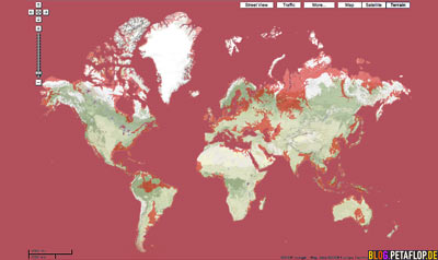
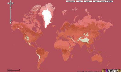
This is how the world map changes if the sea level rises 100 m (328 ft) (red). The shape of North America and Africa don’t change that much. Other continents don’t recognize themselves anymore.
Der Anstieg des Meeresspiegels hätte frappierende Auswirkungen auf die heute bekannten Weltkarte. Bei 100 Metern sehen Nordamerika und Afrika zwar weitgehend unverändert aus, die anderen Kontinente hingegen sind nicht mehr sie selbst.
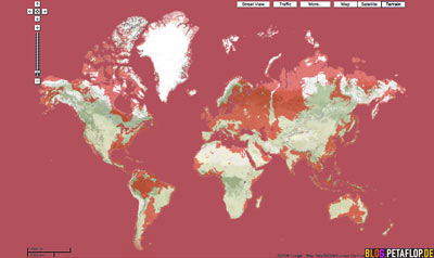
At 200 m (656 feet) most parts of Europe, the half of South America and half Australia are flooded. Southeast Asia is history. Asia looks like a swinging monkey. The dispute question where Europe ends and Asia begins doesn’t bother anymore.
Bei 200 m sind die größten Teile Europas, halb Südamerika und halb Australien bereits überflutet. Südostasien war einmal und Asien hat die Form eines schwingenden Affens. Die Streitfrage, wo Europa aufhört und Asien beginnt, hat sich erledigt.
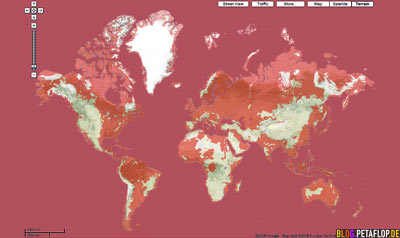
At 400m the shape of North West America looks like a tornado, in South America you clearly see the long island of the Andes. There are only some islands where West Africa once was and Australia is as small as Great Britain before sinking. The leftovers of Europe are Spain, the Alps, parts of Southern Europe and the Scandinavian Mountains. Only Greenland seems to be unimpressed.
Nach einem Meeresspiegelanstieg auf 400 m sieht NordWest-Amerika aus wie ein Tornado, bei Südamerika sieht man deutlich die lange Insel der Anden. Wo einst Westafrika war sind nur noch Inseln und Australien ist so groß wie Großbritannien, bevor es unterging. Europas Überreste sind Spanien, die Alpen, Teile Südeuropas und das skandinavische Gebirge. Nur Grönland bekommt von alledem nichts mit.
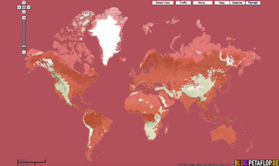
This is how our planet looks like, when the sea level ascends to 800 Meters (2624 feet). The world population evaded to South Africa, China, Greenland and the slender stripes of the Americas.
So sieht die Erde aus bei 800 m ü. NN. Die Weltbevölkerung musste nach Südafrika, China, Grönland und zu den schmalen amerikanischen Streifen ausweichen.
Now it gets really tight. At 1600 m (5250 ft.) all former continents are underwater. Realties in the Chinese mountains, the American Rockies and Andes are really expensive now. Giant swimming cities are mooraged to the peaks of the European Alps. Certainly the highest mountain is still the Nepalese / Tibetan Mount Everest, but now with just 7248 m (23780 ft). Only Greenland still has continental dimensions.
Jetzt wirds wirklich eng. 1600 m Meeresanstieg – alle ehemaligen Kontinente stehen unter Wasser. Grundstücke in den chinesischen Bergen, den amerikanischen Rocky Mountains und Anden sind echt teuer. Riesige, schwimmende Städte liegen vor den Bergspitzen der europäischen Alpen. Der höchste Berg ist natürlich noch immer der nepalesisch-tibetanische Mount Everest, jetzt aber mit nur noch 7248 Metern. Nur Grönland hat noch kontinentale Ausmaße.
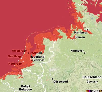
Back to reality: This is what happens to the Belgian, Dutch and German North Sea coast, when the sea level rises 1 m (3 feet) and if we don’t get our levees higher. Scientific predictions differ a lot: The Intergovernmental Panel on Climate Change (IPPC) prognosticates a sea level rise between 18 to 59 cm (0,6 to 1,9 feet) until the end of this century, leaving out the possible collapse of the world’s ice shields, because of it’s incalculability. Jim Hansen, the directing NASA climatologist, fears a rise up to 5 m (16 ft) for the same period. 10% of the world population lives in coastal regions below 5 m elevation. (All maps made wit Google’s Sea Level Rise Simulator)
Zurück zur Realität: So sieht die belgisch-niederländisch-deutsche Küste aus, wenn das Meer um 1 Meter ansteigt und wir bis dahin nicht alles dicht haben mit höheren Deichen. Wissenschaftliche Prognosen gehen stark auseinander. Der Weltklimarat (IPCC) sagt bis zum Ende dieses Jahrhunderts einen Anstieg von 18 bis 59 cm voraus, lässt dabei einen möglichen Kollaps der Eisschilde wegen seiner schwierigen Berechnung aussen vor. Jim Hansen, der leitende Klimawissenschaftler der US-Raumfahrtbehörde NASA, befürchtet im gleichen Zeitraum einen Anstieg von bis zu 5 Metern. 10% der Weltbevölkerung wohnt in Küstenregionen unter 5 Meter ü. NN. (Alle Landkarten wurden mit Googles Meeresanstiegs-Simulator erstellt)
:-) + :-(
Ich habe noch einen Geheimtipp für eine Abenteuerreise, solange es noch möglich ist: die exotische Mikronation Sealand.
Äußerst lesenswerte Entstehungsgeschichte:
http://de.wikipedia.org/wiki/Sealand
Wow, irre.
«Das Gericht stellte in seinem Urteil fest, dass Sealand kein Staat sei, da es weder ein Staatsgebiet noch ein Staatsvolk habe. Das Gericht war der Auffassung, bei der künstlichen Plattform handele es sich nicht um „Landgebiet“. Dazu sei ein Stück „Erdboden“ erforderlich. Da die Plattform nur über Betonpfeiler mit dem Boden verbunden ist, sei sie nicht einmal Teil der Erdoberfläche.»
I wanna go diving in Paraguay
Mit der Gondel durch New York. Oder die legen die Strassen halt höher. Häuser sind ja fast alle hoch genug.
Nur zur Info: habe irgendwo gelesen, dass wenn jegliches Poleis plötzlich schmilzte, der Meeresspiegel um ca. 60 Meter anstiege.
Sten: und was ist mit den gigantischen Wassermeteoren, die in die Ozeane stürzen?
where is belgian?
belgian is next to dutch, near german, north of french
global warming to almost the entire population of IPCC’s annex 1 countries is a virtual problem in that curbing carbon emissions isnt going to mean much to anyone there without a cyber-nature to experience it in. i think that shit like this is crucial if any kind of global warming policy is going to initiate the REAL social reorganization that needs to happen in order to mitigate effects like sea level rise.
Frage: Wie kommt man an dieses Kartenmaterial? Sieht ja fast nach einer Google-Maps-Variante aus. Würde mich über Hinweise sehr freuen!!!
Micha: Siehe Text, ganz unten. Der Link geht allerdings nicht mehr. Habe auf die Schnelle das hier gefunden: http://flood.firetree.net/
Hey, could you provide enlarged pictures please? I’d like to see certain areas more closely.
can you add the volume weight of water on the ocean floor drops 200 m 1000 m at the same time it goes up 100 m 1600 m
Between 1 and 8700 meters above sea level, difficult American keeps increasing
known ocean side can only mountains of europe climate.
Population size continues until death, go away mountains has weird.
Whenever another planet mars is the great infinite ocean, side volume is more
future we have god including Jehovah’s Witnesses want then limited.
Sea levels will almost certainly rise 200 m by 2020. But that is not the ‘problem’. The ‘problem’ is three things:
FIRST: the very many (earthquake, seaquake, Earth fall on its axis, etc. generated) giant tidal waves cum large areas of land to consequentially both sink under the weight of which water and rise in parts; that millions have dreamt about, scheduled for the not too distant future.
SECOND: the fact that said events have been delayed and as a consequence will now manifest more multifocally, with greater intensity and over a shorter time frame. Ergo, instead of the aforesaid earth fall generating mile high waves, it will now likely generate league high waves.
THIRD: Too many folk still seeing said and other aspects of a Solution as ‘problems’ cum black as white and white as black, generally; etc., etc. And thus
necessitating said Solution.
“Sea levels will almost certainly rise 200 m by 2020″…Almost certainly? This is not physically possible, so it’s certainly not true. You have to have enough ice to melt, an you have to have enough energy to melt it. We know about how much ice we have, and we know how much energy comes into our system every year. There’s not enough of either to make this happen. It would take millennia to melt all the ice we have. No, GHGs can not create energy—they just slow down the release of what comes in from the sun. And a finite amount of energy can melt a finite amount of ice.
And what’s the point of this 400-800-1600 meter stuff? I believe that 200 m is the difference between the peak of the last ice age (sea level low) and the peak if everything melted. Why do people worry about 400 m if it’s impossible—expecting to import water from another planet?
I realize this is an old article, but it’s a “what if” than “can’t be”.
Is it real?I am a Chinese.I live in Shenzhen.My city just 70 meters high.But we have Yangtai Mountain(587 Meters high)and Wutong Mountain(943 Meters high).